| Locator | Hist Soc - HS-A08824 | Type | Drawing | Doc Number | N-7500 | |
|---|---|---|---|---|---|---|
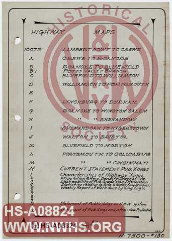
| Description | Index to Highway Maps, drawings 10072 showing grade crossings. | |||||
| Notes | Sheet 130. | |||||
| Date | Revision Date | |||||
| Author | N&W Rwy - Office Chief Engr | Accession | 2005.004 : Library of Virginia | |||
|
|

|
|
Size: 6in x 9in (15cm x 22cm) |
| Parent | N-7500 | Hollinger - Hol-01011.20 | Index to Sheets to N-7500 4 pages. Individual sheets/sets linked. Not all sheets were in folder. Missing sheets: 34 (have A,B,C), 84A (have 84,B,C), 96, 112, 114, 115, 117, 135 (have 135A), 141,141A,141B (have 141C, D1, D2), 144 (have A,B). |
| Child | 10072-3 | Hist Soc - HS-D00089 | Table Showing Desirability of Public Grade Crossing Elimination, Protection or View Improvement |
| Child | 10072-J | Hist Soc - HS-CC00479 | N&W Ry Co. Map showing state highway crossings on Radford division Map shows Roanoke to Bluefield & Bristol with major branches and highways that follow them |
| Child | 10072-12 | Hist Soc - HS-W00123 | N&W Rwy, Statement of Public Crossing on System, Protected by .... Large Chart. Crossing protection type (gates, watchman/flagman, audible and/or visual signals) by state / line segment. |
| Child | 10072-12 | Hist Soc - HS-W00124 | N&W Rwy, Statement of Public Crossing on System, Protected by .... Large Chart. Crossing protection type (gates, watchman/flagman, audible and/or visual signals) by state / line segment. |
| Child | 10072 | Hist Soc - HS-U00223 | N&W Rwy, Norfolk Division, Situation Plan of Highways, Lambert's Point to Crewe. Map and tables list road crossing characteristics, protection type, and proposed elimination. |
| Child | 10072 | Hist Soc - HS-U00224 | N&W Rwy, Norfolk Division, Situation Plan of Highways, Lambert's Point to Crewe. Map and tables list road crossing characteristics, protection type, and proposed elimination. |
| Child | 10072A | Hist Soc - HS-U00225 | N&W Rwy, Norfolk Division, Situation Plan of Highways, Crewe to Roanoke.. Map and tables list road crossing characteristics, protection type, and proposed elimination. |
| Child | 10072C | Hist Soc - HS-U00226 | N&W Rwy, Pocahontas Division, Situation Plan of Highways, Bluefield to Williamson Map and tables list road crossing characteristics and protection type. |
| Child | 10072D | Hist Soc - HS-U00227 | N&W Rwy, Scioto Division, Situation Plan of Highways, Williamson to Portsmouth Map and tables list road crossing characteristics and protection type. |
| Child | 10072F | Hist Soc - HS-U00228 | N&W Rwy, Norfolk Division - Durham District, Situation Plan of Highways, Lynchburg to Durham Map and tables list road crossing characteristics and protection type. |
| Child | 10072G | Hist Soc - HS-U00229 | N&W Rwy, Shenandoah Division - Winston-Salem District, Situation Plan of Highways, Roanoke to Winston-Salem Map and tables listing road crossing characteristics and protection type. |
| Child | 10072H | Hist Soc - HS-U00230 | N&W Rwy, Shenandoah Division, Situation Plan of Highways, Roanoke to Shenandoah Map and tables listing road crossing characteristics and protection type. Map shows ore branches out of Shenandoah - Shenandoah Ore Branch, Smith Ore Branch, Fox Mt. Branch |
| Child | 10072I | Hist Soc - HS-U00231 | N&W Rwy, Shenandoah Division, Situation Plan of Highways, Shenandoah to Hagerstown Map and tables listing road crossing characteristics and protection type. Map shows ore branches out of Shenandoah - Shenandoah Ore Branch, Smith Ore Branch, Fox. Mt. Branch |
| Child | 10072J | Hist Soc - HS-U00232 | N&W Rwy, Radford Division, Situation Plan of Highways, Walton to Bristol Map and tables listing road crossing characteristics and protection type. Includes Abingdon Branch, Saltville Branch, Radford Branch, North Carolina Branch and its branches. |
| Child | 10072-10 | Hist Soc - HS-H00612 | N&W Ry, Statement of Public Crossings on System Organized by state and line. Gives info on number of highway crossings and watchman, automated, gates, etc. |
| Child | 10072-2 | Hist Soc - HS-C02272 | N&W Ry, Population and Highway Density Chart of Virginia By County, |
| Child | 10072-5 | Hist Soc - HS-A06503 | Weekly Report to Chief Engineer of Work done by Crossing Engineer Blank form. |
| Child | 10072-4 | Hist Soc - HS-B07185 | N&W Rwy, Statistics Relative to Automobiles, Automobile Accidents, and Grade Crossing Accindents per Year Covers years 1910-1922, 1923 partially filled out. |
| Child | 10072-B-1 | Hist Soc - HS-C02283 | N&W Rwy, Radford Division - Potts Valley Branch, Situation Plan of Highways, MP 14-38. |
| Child | 10072L | Hist Soc - HS-U00438 | N&W Ry Co. Scioto Division. Situation Plan of Highways, Portsmouth to Columbus. Scale 1"=1 mile. |
| Child | 10072-M | Hist Soc - HS-U00758 | N&W Rwy, Scioto Division, Situation Plan of Highways, Portsmouth to Cincinnati scale 1"=1 mile. |